![]()
Featured Stories
Black Star and Other History Facts
"Probably without knowledge
of the padres at San Juan Capistrano,
a party of hunters led by William Wolfskill visited Orange
County
in 1831. They had come to Los Angeles
from New Mexico and, knowing that strangers were unpopular, they sought to
ingratiate themselves with the local authorities by undertaking to track down a
band of Indian horse thieves. The trail led them into the Santa Ana
Mountains
where they entered Canon de los Indios (Canyon of the Indians). Here they
discovered an Indian camp where the red men were gorging themselves on a feast
of stolen horsemeat. Silently they moved into position and commenced firing. Few
of the Indians survived the bloody massacre. The stolen horses were rounded up
and herded back to their owners. With the discovery of coal, the name of Canon
de los Indios was changed to Black
Star
Canyon."
(Pp. 15–16, "Orange County Through Four Centuries" by Leo J. Friis)
"1832—Indian massacre in Black Star Canyon" (P. 18, "Jim Sleeper's 3rd Orange County Almanac")
"Little mentioned today was (William) Wolfskill's most dramatic contribution to local history. Shortly after arriving in Los Angeles in 1832, he displayed his skills as a tracker by leading a party of rifle-toting frontiersmen after a band of Indian horse thieves. Trailed to their hideout in Black Star Canyon, several miles above Irvine Park, the renegades were surrounded and slaughtered to a man. The incident gave Orange County its one claim to an ‘Indian massacre.'" (P. 8, "Bears to Briquets, A History of Irvine Park" by Jim Sleeper)
"North of the Aliso lived the Gabrielinos; south lived the Juanenos. Both were of Shoshonean stock—shirttail relatives of the buffalo-hunting Comanches of the Great Plains and the peace-loving Hopis of the Arizona mesas. As the local Indians' names for themselves, Kawengna and Acagchemen, were as unmanageable to the Spanish as they are to us, they were called by the closest mission to which they belonged—Gabrielino for Mission San Gabriel; Juaneno for San Juan Capistrano." (P. 21, "A Grizzly Introduction to the Santa Ana Mountains" by Jim Sleeper)
"Near this chimney the old road left the canyon
bottom, and a three-mile climb on a steep ridge was necessary before we reached
the Hidden Ranch. Today, the forest road leaves the canyon at the same point,
but its route to the top is one of many switchbacks, made to reduce the grade….
We had been given descriptions of the old Indian campgrounds, so we looked for a
knoll soon after we came in sight of a quiet canyon with a house and barn and
corral not a half-mile away. We found the knoll not more than twenty yards off
the road…. Just at the edge of the grove of oaks we found the first unmistakable
sign of early Indian habitation. It was a boulder six or eight feet long with
five deep grinder holes worked into it…. Before us was a small hill, covered
over with stunted and broken oaks.
 Beneath the trees were piles of boulders,
scores of boulders, some of them buried deep in the earth with only a part
exposed. Worn into these boulders were dozens and scores of deep grinder holes.
I know of no place in all the mountains where grinder holes are to be found in
such numbers, one, two or perhaps a dozen on a boulder…. In an open space,
partly surrounded by trees and sandstone boulders, ancient campfires burned,
perhaps years upon years without going out. The soil is here black as peat,
greasy from the refuse of the camp, with bits of charcoal in it…. We found that
the knoll broke off sharply into a steep canyon bottom…. Others afoot may take
time to explore the gorge of the Black
Star
Canyon,
a chasm that has been torn out of solid rock. With its rough walls, it is one of
the most picturesque spots in the mountains. This gorge comes to an end in a
sheer precipice of perhaps 150 feet, down which waters pour during the season of
the year when a stream is flowing in the Black Star. Both times that I have seen
the gorge I entered from below the Hidden Ranch house, passing by the foot of
the hill on which the Indian village is located. At the foot of the hill, from
the solid bedrock, flows a spring, famed among those who know the mountains as a
spring that even in the driest years never lessens its flow. This spring,
perhaps, was one of the reasons why the Indians selected the knoll above it for
a home." (Pp. 107-113, "Shadows of Old Saddleback" by Terry E. Stephenson)
Beneath the trees were piles of boulders,
scores of boulders, some of them buried deep in the earth with only a part
exposed. Worn into these boulders were dozens and scores of deep grinder holes.
I know of no place in all the mountains where grinder holes are to be found in
such numbers, one, two or perhaps a dozen on a boulder…. In an open space,
partly surrounded by trees and sandstone boulders, ancient campfires burned,
perhaps years upon years without going out. The soil is here black as peat,
greasy from the refuse of the camp, with bits of charcoal in it…. We found that
the knoll broke off sharply into a steep canyon bottom…. Others afoot may take
time to explore the gorge of the Black
Star
Canyon,
a chasm that has been torn out of solid rock. With its rough walls, it is one of
the most picturesque spots in the mountains. This gorge comes to an end in a
sheer precipice of perhaps 150 feet, down which waters pour during the season of
the year when a stream is flowing in the Black Star. Both times that I have seen
the gorge I entered from below the Hidden Ranch house, passing by the foot of
the hill on which the Indian village is located. At the foot of the hill, from
the solid bedrock, flows a spring, famed among those who know the mountains as a
spring that even in the driest years never lessens its flow. This spring,
perhaps, was one of the reasons why the Indians selected the knoll above it for
a home." (Pp. 107-113, "Shadows of Old Saddleback" by Terry E. Stephenson)
The Answer
Bad Religion song
Sent to us by Jesse Beck
The Answer
long ago in a dusty village,
full of hunger, pain and strife,
a man came forth with a vision of truth,
and the way to a better life,
he was convinced he had the answer,
and he compelled people to follow along,
but the hunger never vanished,
and the man was banished,
and the village dried up and died,
at a time when wise men peered,
through brass tubes toward the sky,
the heavens changed in predictable ways,
and one man was able to find,
that he had thought he found the answer,
and he was quick to write his revelation,
but as they were scrutinized
in his colleagues eyes,
he soon became a mockery,
don't tell me about the answer,
‘cause then another one will come along soon,
I don't believe you have the answer,
I've got ideas too,
but if you've got enough naiveté,
and you've got conviction,
then the answer is perfect for you
an urban sprawl sits choking on its discharge,
overwhelmed by industry,
searching for a modern day savior
from another place
inclined toward charity,
everyone's begging for an answer,
without regard validity,
the searching never ends,
it goes on and on and on for eternity
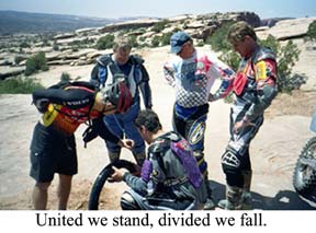
As I watched a mountain biker from the San Francisco Bay Area drip
precious fluids from his CamelBak hydration system onto my friend's motorcycle
tube to help spot an air leak, I was struck by the irony of the situation.
Here is a group of non-motorized trail
enthusiasts helping some dirt bikers on a trail in the Poison Spider Mesa near
Moab, Utah. I have been told by the Sierra Club and other preservationists that
we weren't supposed to get along.
For many years, green groups have cited so-called user conflict between motorized and non-motorized recreationists as a reason to close lands to off-highway vehicles (OHVs). A recent 68-page, "the sky is falling" report authored by the California Wilderness Coalition said that hikers, campers and mountain bikers have been run off the land by OHVs.
Yet, here I am in the mountain bike and hiking capitol of the world enjoying the scenic wonders of this special place, and it seems that the non-motorized recreationists have not heard that they are supposed to yell at jeepers and OHVers for "ruining" their solitude and enjoyment of the great outdoors.
As several of us dirt bikers dismount and hike out to a vista overlooking the Colorado River, we are greeted by some tourists who hired a local guide to drive them in a four-wheel drive. At the same time, four mountain bikers also park their bikes and join us as we all take in the beauty and grandeur of the canyon and view.
The hikers we passed on the Poison Spider Trail waved at us and smiled. They said they were having a great time and told us to enjoy our ride. Maybe this is a dream. But no, it is real. As the one mountain biker helped locate a slow air leak in Randy Block's tire tube, I chatted with the other riders visiting this area from California. Instead of pointing fingers at each other, we talked about the price of my Michelin S-12 knobbies and that their mountain bike tires also cost about 65 dollars each.
 I asked them if they had ever ridden at
one of my other favorite trail areas near Downieville, California. Located in
the Sierra Nevada, this popular multi-use trail system is yet another example of
where I have experienced a "we can get along" philosophy. I go there every year,
and it seems that the equestrians, OHVers and mountain bikers have managed to
craft a land-use ethic that respects other trail users and the environment.
I asked them if they had ever ridden at
one of my other favorite trail areas near Downieville, California. Located in
the Sierra Nevada, this popular multi-use trail system is yet another example of
where I have experienced a "we can get along" philosophy. I go there every year,
and it seems that the equestrians, OHVers and mountain bikers have managed to
craft a land-use ethic that respects other trail users and the environment.
Am I naive enough to believe that there are never any instances of some trail users having disagreements with other recreationists? No. However, I do believe that there are many places where diverse recreational interests can and do manage to use public lands in a cooperative fashion.
I have a dream that someday all trail users will get along and respect each other's personal choice of recreational activity. Maybe that's not such a far-fetched idea.
|
Ya Ta Hey / Club and General News |
Blue Ribbon Coalition News and Guest Commentary
Late Breaking News and Closing Thoughts
|