Smoke Signals
September 2000
Warriors,
Summer is almost over and what a summer it was! We've redesigned our web site and have been busy planning our 2000-2001 trail work and riding events. We finished up our last trail maintenance for 1999-2000 in June, installing motorcycle gates at 3 locations. This was one heck of a project.
We have some good stories in this issue as well as several articles on a few developments that will affect the Cleveland National Forest, some for good and some for bad. We thank you all for your submissions and encourage you to keep them coming.
So without further ado, here's the
September Issue of Smoke Signals.
Proposed
Road Through the Santa Ana's
Riverside public officials have begun a study proposing a 4 to 6 lane road across the Santa Ana's to eliminate the congestion on the 91 Freeway, which is expected to double to 450,000 cars a day. This increase in volume will be due to development in Riverside County, some of which will benefit workers who are finding it increasingly hard to buy a house in Orange County. In five years it is estimated that 95,000 additional houses will be built in Riverside County.
Engineers are studying three major corridors through the Cleveland National Forest. They include; a route from Cajalco Road in Corona to the Foothill (241) Toll Road; A route from Lake Elsinore to San Juan Capistrano near the Ortega Highway; and a route from Temecula to San Clemente. Only one alignment, if any, would be chosen, officials said.
The concept, still in the early planning stages, would cost at least $2-3 billion to build a 15- to 20-mile road. It would be difficult to avoid environmentally sensitive areas, planners concede, with two of the alternative routes tunneling through the Santa Ana Mountains. In addition, Riverside is still trying to secure money for further study of the routes. This development has been tossed about for years but has recently been seriously studied.
The Orange County corridor is one of four routes the Riverside County Transportation Commission has agreed to study as part of a three-year, $20 million planning effort to solve future traffic congestion.
Part of the plan includes expanding Metrolink service, adding more buses between the counties and possibly expanding the 91 freeway.
If such a road is approved after extensive planning and public input in both counties, the U.S. Forest Service will try to work with planners and agencies to minimize environmental disruption, said Forest Service biologist Mary Thomas.
A busy highway would be especially hard on mountain lions, which require 30 to 40-square-mile ranges and do not adapt well to human development. Depending on the route selected, the road could interfere with habitat for the endangered Arroyo Southwestern Toad and Least Bell's Vireo, as well as the threatened California Gnatcatcher.
One route also could affect some part of the Nature Reserve of Orange County, a 37,000-acre wildlife reserve created in 1996.
I
alerted those on our email list to this news and posted the article taken from
the Orange County Register on our web site. Some of the information above was
taken from that article.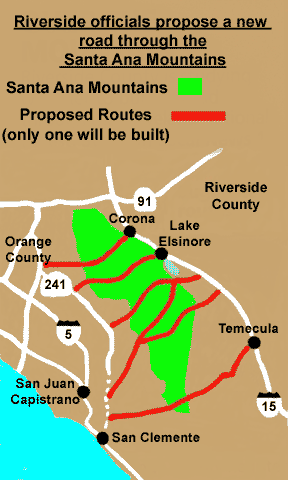
One concern that was not mentioned, but will have a dramatic effect on the adjoining Forest, is the water runoff generated by storms and the particulate and liquid matter from tires, trash, oil, gas and coolant contained in this water. During peak storm seasons, more than 100 inches of rain fall on these mountains. Where would this water be channeled? Even if a portion of the road were a tunnel this would still be a factor.
We have seen the destruction the water runoff has caused in Laguna Beach from the 74 Toll Road. Water that would normally go into various small canyons and drainages would have to be diverted to areas where it could be controlled. Will this cause increased erosion and damage to the areas where the water is directed?
The Forest Service is already taking action to protect endangered species, including closing areas. Will this road only increase the impact on those endangered species and cause more closures?
On the flip side, I believe within 15 years, Orange County will be built out. If you don't own a house now, due to supply and demand, it will be increasingly difficult to do so. The median price of a house in Orange County is now around $240,000. In 15 years it could conceivably be around $400,000 or more.
There is already a concern for low paid service workers who are finding it increasingly difficult to find affordable rental housing. Most manufacturers have left or are planning on leaving Orange County for areas that are more affordable. The cost of living and the economic future of Orange County, due to land costs and higher wages needed to attract workers may be threatened.
Why should we be concerned with the economic impact on Orange County? Because most taxpayers, (i.e. voters), are concerned. I think the percentage of voters against this road will be in the minority (residents adjacent to the proposed road and Forest users and activists), with the majority of voters supporting the road (or ambivalent).
Voters will not only support the road because of the so-called economic impact, but because it would provide them with an easier commute out of Orange County to the Colorado River, Palm Springs and all points east.
Though politicians say they must overcome public opposition, they are aware that it will be the minority mentioned above they will have to deal with. If the majority of voters support the road, they will not be as concerned with the political impact of isolating and angering the minority of voters against it. A good example of this is the 73 San Joaquin Transportation Corridor.
Politicians know that their only problem will be to get around the environmental concerns. The Sierra Club has attempted to change the designation of areas that could be impacted by the road to wilderness areas, but all it would take is congress to ok a waiver and the road would still go through. Like I mentioned, I don't think the majority of the public would mind.
Another point to bring up is if the route from Cajalco Road in Corona to the Foothill (241) Toll Road is built it could possibly make it easier for the Irvine Company to build up the undeveloped area between the Irvine Park and Blackstar Canyon. One of the reasons they haven't done this is because of the impact on Santiago Canyon Road. A road running past Irvine Lake with exits and on ramps would eliminate this problem. You can expect the Irvine Company to support this route.
There is so much political and public support for the road that it will be hard to overcome its' construction if the funding is raised, which I don't see happening within the next 5 years.
In addition, there are also plans in development to construct a major water line across the Santa Ana's from the reservoirs in Riverside to supply water to Orange County. Imported water accounts for about 80% of the water used in Southern California, which for all accounts is a semi-arid environment. Water is life and I doubt you will get too many citizens against having this pipeline built.
There are several things that could delay or prevent the building of this road. The first would be for the State to purchase the 91 Freeway toll lanes (the operators would be more than willing to sell). This would void the agreement whereby the state is prevented from improving the freeway to prevent competition with the toll lanes. This would also allow the state to purchase additional right-of-way and increase the capacity of the 91 Freeway. This would be far cheaper than spending 2-3 billion for a new road.
Market forces such as a recession or the elevation of gas prices, which has already resulted in an increase in use of the Metrolink system from Riverside, would also put a damper on building the road. Expansion of the Metrolink (suggested by John Mckenzie in an email sent to us) is another option that would make more sense than a road if rising gas prices force people out of their cars. A combination of additional lanes and increased (and convenient) Metrolink service would be a far better idea both environmentally and fiscally.
It has been suggested that if the road is to be built two actions should be taken. One is to build the water line along the route of the road to prevent additional impact on the forest. The second is to build a toll road, preferably using a tunnel to minimize the impact to the surrounding area, with a guaranteed portion of the tolls going towards maintenance and endangered species mitigation in the Trabuco District of the Cleveland National Forest where the road will be built.
One of the main problems facing the Trabuco District (and many forests) is a lack of funds for maintenance. Some forests generate revenue by mining or recreational leases (ski resorts). The Trabuco District, and I believe most of the Cleveland National Forest, has no such revenue generating activity (aside from the Adventure pass).
Money is needed to repair the water crossings and canyon roads at both Maple Springs and Trabuco Canyon to prevent further degradation of the streams due to vehicle caused disturbance of the streambed and erosion. There are other areas in need of repair to prevent further degradation but no money to pay for it.
If we can't stop the road (which is our first priority) we must demand, that either by a portion of the tolls or by mitigation fees or agreements, that these other areas in need of repair be taken care of. We must also demand that the area impacted by the road and its water runoff is monitored. Actions must be taken to prevent contamination and degradation of habitat during construction with the monitoring continuing after the road is built.
At the Trabuco Creek Bikeway Bridge dedication I mentioned these concerns to County Supervisors Todd Spitzer and Tom Wilson. I will write about this and the bridge dedication in the December issue of Smoke Signals.
I don't want anyone to think that the Warrior's Society supports a road through the Santa Ana's, but we must be aware of the political realities; to do otherwise is foolish. We must express to the public our concerns of what the impact of this road will be on the forest for generations to come. If we cannot do this in an effective, peaceful and inspired fashion, all will be lost.
We
will keep you informed as this situation develops.
Your Thoughts on the Road
John
McKenzie
Via email
To me the Cadalco Road to 241 alternative might be the top contender amongst the alternative routes the Register mentions. This would allow the proponents of the road to use the same environmental documents and impact mitigation practices that brought us the 241 and 261 toll roads because the Cadalco Rd. to 241 route is in the same area that has been already analyzed.
Thus they wouldn't have to start from the ground up in the analyses of the area. Also less analyses means less money. They would have to expand on some things and recalculate impacts because the flow of traffic would increase beyond the current levels on the 241 and 261.
I tell you one thing; that 1 billion sure would buy a lot of light rail run down the centers of the 91 and 55 freeways. But at this time I don't see any other modes being discussed other than expansion of Metrolink service on an already congested rail corridor.
The road and its' waterline, regardless of which alternative they use of the three, is going to spur development. Chances are this will take place at the places where the road/water line connects to existing roads and water lines.
If the road is in fact going to be built, it may be time to begin to develop ideas on developmental restrictions to the area. These cannot only be environmental but also cultural and historically based. Looking at a topographical map of the area one can interpret there are numerous sites within the area that connect us with the past of Orange County.
Ned
"Lone Wolf" Reynolds
Via email
Back on 2-18-98 the Orange County Register printed an article detailing a road through the heart of Chino Hills State Park for the purpose of connecting the 71 with the 91 near Green River Drive. The So Cal Assoc. of Governments (AKA "SCAG") held a meeting at the Santa Ana Senior Center the same night. The turnout was light for that one but the next day another meeting was held at the Brea Civic Center as part of the Orange County Council of Governments. The Council Members had almost no idea about the proposal and it was extremely pleasurable to watch and listen to these people get blindsided. The place was packed and not one person spoke in favor of the road. Haven't heard a word about that road since.
Again I see a road drawn thru the path of least resistance. These people who dream up this stuff would turn the Grand Canyon into a landfill and then build a Taco Bell on top of it if it would make them five extra dollars. They have ZERO pride in their community. All they want to do is live cheap and get to work ten minutes earlier. If there are any public hearings on this matter I'd love to go and blow off some steam so keep me informed.
Mike
MacDavid
Via email
This proposal itself is a disaster! The wreckage inflicted on the Forest could never be mitigated. The only silver linings might be that a widened road based on an existing pathway (Ortega Highway) might both limit
Environmental destruction (much was already completed with the Ortega) and provide increased momentum for expansion of Ontario International so El Toro International NEVER becomes a reality. Either way, it's a lose/lose situation.
Thanks
for sending the information!
Coal Canyon Preserved
By
PAT BRENNAN
The Orange County Register
COAL CANYON -- A vital mountain lion corridor in northern Orange County that was nearly erased to make way for housing will instead be preserved as wilderness under a $40 million purchase agreement.
The price represents a $10 million discount; the property had been appraised at $50 million. But the owner, Steven St. Clair of the St. Clair Co. in Newport Beach, said he changed his mind about placing as many as 1,550 homes, a school and a commercial center on the 649-acre site after talking to wildlife agencies. He gave the discount to help activists struggling to pull together funding.
"When we started understanding how critical this property was, and how important it was as a link for habitat for miles and miles of open space, we decided to see if we might be able to put a deal together," he said.
The
purchase, approved Friday by the state Public Works Board in Sacramento and paid
for by a variety of contributors, including Orange County, was celebrated Friday
by environmental activists. "Getting it preserved as open space is the
right thing to do," said Claire Schlotterbeck, who has pushed for four
years to save the property.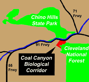
Coal Canyon was considered a high priority for preservation by state parks officials. It is the last remaining link for lions and many other animals between the Cleveland National Forest and the Chino Hills; blocking it could have caused local extinctions in the Chino Hills and further shrunken an already dwindling range for lions to roam.
It also would have turned Chino Hills State Park into an "island" of habitat, with no connection to the forest, a vital source of seeds for native plants. Without lions and other large predators, there could be an explosion in mid-size predators in the park, causing populations of native songbirds to nose-dive.
Where the $40 million to buy the habitat corridor came from: State Department of Parks and Recreation $4.7 million, California Transportation Commission Transportation Enhancement Act $15 million, Wildlife Conservation Board $4 million, Orange County $1 million, Pulte Home Corp. habitat mitigation fund $10 million, Wildlands Conservancy $2.5 million, anonymous donors: $2.3 million, Fieldstead and Co.: $500,000
Porter Ranch Property
Donated to County
By
JIM RADCLIFFE
The Orange County Register
TRABUCO CANYON -- A large chunk of the colorful Porter Ranch will become county property as early as Friday, ensuring that a corner of this rustic community will stay pretty much like it always was.
In recent years Jeanne Porter, the widow of feisty rancher Sam Porter, pondered how to keep the family's 233-acre spread wild but still somehow raise some money to pay the bills.
She once said that if she sold the land, she would be long gone before the construction crews rolled in because watching the earth become concrete would be too tough to take. When the nonprofit, San Francisco-based Trust for Public Land stepped in and agreed to purchase 113 acres tucked into the Cleveland National Forest for $440,000 -- the appraised value -- she bit.
The trust will turn around and sell the land for the same price to the county, which could hold onto the isolated parcel until linking it to one of two nearby regional parks, O'Neill or Caspers, or deeding it to the forest.
Porter will continue living on the ranch's remaining, adjacent 120 acres. "I'm excited, of course, because it is going to remain open space - I don't have to worry about bulldozers or somebody tearing (the natural surroundings) down," she said Wednesday. "It's part of me - or I'm part of it, I don't know. "I feel like I'm giving up a part of me, because we've been out here so long. But overall, it feels like a good thing.''
Sam Porter - gruff, lanky and more colorful than a painter's palette - purchased the 120 acres that his family will hold onto in 1977. Three years later, the rancher and cement contractor bought the 113 acres that his wife is selling.
Before his death in 1996, Sam Porter warred with the water district and developers and battled the county over Porterville, his shantytown where Mexican laborers lived. With the trust acting as middleman, the sale can go through quicker. Escrow could close as early as Friday.
The property is home to Black Rock Canyon, house-sized stones, and sycamore and alder trees. County staffers say they envision people eventually hiking, picnicking and fishing in trout- stocked Trabuco Creek, which runs through the property. Although residents of Holy Jim, a small cluster of cabins in the national forest, take a dirt road through the property to get to their homes, the county considers the property inaccessible to the public.
Someday, a county document says, additional land might be acquired by the county so it can link this portion of the Porter Ranch to O'Neill or Caspers. The closest of the two is O'Neill - separated by nearly two miles of privately owned land.
Supervisor
Todd Spitzer said that besides ensuring that the land isn't developed, the
purchase was made so the county could use the property as a bargaining chip with
the federal government. The county's lease on land where it operates the Los
Pinos Conservation Camp for youthful offenders expires next year. Negotiations
are stalled for a new lease - the supervisors will offer up the Porter Ranch
parcel in exchange for "significant concessions'' on the Los Pinos lease,
he said.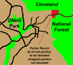
County department heads last month listed acquisition of the 125-bed Los Pinos facility -- on which the county has spent $8 million for renovations -- as one of the top 10 priorities for the county in 2001. At a workshop last week, supervisors endorsed that view.
Keeping the rugged Porter Ranch property pristine sounds good to the locals. Sharon Banning, 56, lives with her husband in a 1930s-era cabin in Trabuco Canyon and wants the area's rolling hills to stay sparse with development. She said she would prefer the county buy land that it could quickly turn over to the public, but this property purchase is a good thing.
"I'm pleased they are buying totally undevelopable land and are keeping it undeveloped,'' Banning said. "Pin a rose on their nose."
Register staff writer Peter Larsen contributed to this report.
"To respect the Earth and to respect each other, to respect ourselves, to respect life itself. That's our first commandment. That's the first line of our Gospel"
Mathew King
Lakota
Club
News
So far the consensus is to keep the requirement of 10 hours of volunteer time doing trail work, supporting our events, or contributing to Smoke Signals to maintain your membership in the Warrior's Society. If you disagree with this requirement now is the time to speak up. My main goal when I decided on this requirement was to keep the club dynamic and effective in achieving our goals. So far it has worked.
It was not a pleasant thing for me to do when I removed 3 people from the club because they did not donate the time. So far this year we have 3 members who have not donated any time to helping with the trail work or events. I will feel a lot better knowing the club agrees with this requirement.
The Warrior's Society in which we are based did not honor braves who were capable of fighting to protect the land but declined to do so. When I started this club I wanted to stick as close to the traditions of the Society as possible.
Two
things our 10-hour requirement teaches us is what symbolized the Warrior's
Society - sacrifice and commitment. My fellow Society members, in what better
way is there to honor all our sport has given to us than to fight to protect our
trails and our right to use them? The war our spiritual brothers fought was one
of Blood and Death. Our battle will be one of sweat, and intellect. When I say
intellect I mean we must fight the battle to protect our right to use our land
with the argument of reason. We must make the public understand what options
exist and what actions must be taken to prevent the wholesale closures many wish
to impose on us.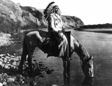
If you are a strong rider, it says a lot about your ability and strength. It is primarily a personal sacrifice for one's self to train and commit the time to do so. But this does not keep the trails open. We expect members to realize and to teach others that the land we ride on is a gift to ourselves and to those who will come after us.
All we ask is that members give the land a little of the sacrifice and commitment they put into their training and riding.
Chay and Brett Peterson's volunteer work with their youth camps and Carl and Mary Jo's work preventing the development of Barnham Ranch also count towards membership. They give back to the community.
As far as the riding seminar is concerned, several members have expressed a desire to participate. What we'll probably do is break the clinic up over 2 weekends with the first weekend concentrating on training, mechanics, and preparation. The second weekend will be the actual ride. We will break up the ride portion according to ability. Those who wish to be instructors think about the topics and write down your ideas so I can start preparing a workbook. Think about what time of year you want to have the clinic, I was thinking about having it before the Pow Wow. I'll contact Dave Strege with the Register and Martin Beck with the Times (as well as Shidan with Bike Mag) so they can have it announced 2 months before and up to the clinic.
The following are the Council Members this year, based on their dedication to the club, as expressed by their hours spent supporting the club: Bob Loeffler, Jesse Vargas, Keith Eckstein, Karl Greenblatt, and Chris Vargas. Our Chief Elder, Bob Haislett, is a permanent member of the Council and keeper of the Club Staff. We will no longer have an Executive Director. All Council Members will be directors with specific areas of responsibility. The Councils Coup Feathers will carry beads with the following colors: red, the color of the Council, and aqua green, the color of next year's Vision Quest beaded feathers. All other Club members will have blue beaded feathers with a red bead if they've finished the Vision Quest or Todd's Park to Park ride.
The
following have been voted in as members of the club and will receive their club
Coup feathers at either the club Cuyamaca ride or at the Toad Festival: Todd
Brown, James Hahn, Ned Reynolds, Greg Groom, Will Boyd, and Colleen Rashford.
Jim Meyer has been nominated as a member of the Warrior's Society Tribe and if
no votes against his membership are received he will receive his Club Coup
feather at the same time as the other nominees. All have contributed to the
success of the club and our goals of protecting and preserving the forest. We
are honored by their membership and welcome them to the Society.
Conflict in the
County and State Parks
A recent article written by Martin Beck of the Los Angeles Times concerning mountain biking in the County and State Park system has sparked more controversy. The issue of illegal trail building was once more brought up and mountain biking was not portrayed in a good light. Some statements were made on both sides of the issue that were incorrect or miss-stated either by ignorance or during the editing process.
I
have found Martin Beck to be a fair person and his article may not reflect what
he wrote if his editor did not accurately edited his story before publication. I
know when I read the story in the in the paper I bought in Santa Barbara while
on vacation it was shorter that the one in the Orange County Edition of the
Times.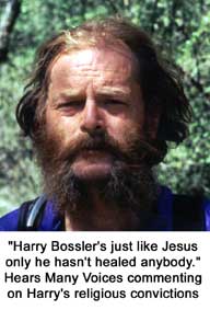
On a related note, "Hears Many Voices" who was angry over his loss of his Club Council position, resigned. He also stated that our lack of participation in the County Parks, namely Caspers, contributed to this decision. I explained to him that the Warrior's Society is primarily concerned with the National Forest and believes that the tribes (clubs) who ride Caspers should be the ones working to keep mountain biking there.
The tribes that primarily uses Caspers are BGR (which "Hears Many Voices" also belongs to) and I believe the "What the fuck " racers. I know that these tribes are well known by both the park rangers and the caretaker of the Audubon Reserve; and not for their trail work.
The reason why we do no work at Aliso/Woods Canyon Park and El Moro State Park is these parks are primarily the lands of both the RAD and Share tribes. If any trail work or actions to protect the right to ride in these parks are to be taken, these tribes must take it.
The Warrior's Society will do all in its' power to protect the land and trails in the Trabuco District of the Cleveland National Forest and the right of mountain bikers and all recreational users to responsibly use it. It is our hope that the tribes in the County and State parks do the same for their lands.
We must all remember; this is not 1987. The impact on these parks will only increase. The illegal trail building (blamed unfairly on the RADS who have ridden in Aliso Woods since it was Irvine Ranch property and not a park) will not stop unless we understand the impact this will have over time.
The tribes must work with the County and State officials to find a balance between the need to protect the land and the recreational use of it. The only way to address the current conflict is to come together on common ground. We must seek peace and focus our eyes not only on the present but also on the future.
In closing I offer some thoughts for these tribes to contemplate on; what is more important, mountain biking or the land? In what condition will you leave this land for future generations?
Peace,
Dances
With Hornets
Orange County
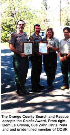
Search and Rescue receives Award
The
U.S. Forest Service for their outstanding public service recently recognized the
Orange County Search and Rescue, one of our Major Sponsors. We congratulate them
on this well deserved recognition.
John
Early's Work Featured by Steve Jobs
One of John Early's
QuickTime VR pano movies he recently produced for Mercedes-Benz S430 has been
chosen by Apple to be showcased during part of Steve Jobs keynote speech at
MacWorld on July 19th and also at their QuickTime kiosk there. You can also
check out Apple's QTVR Showcase where another QuickTime VR movie he produced is
being showcased. This one was for the Acura CL. Congratulations John.
Sue
Zahn Promoted
Dear
Friends,
After 7 1/2 years here on the Trabuco Ranger District on the Cleveland National Forest, the time has come to pack my bags and move on to another position. I have accepted a position in the Angeles National Forest, San Gabriel River Ranger District (Mt Baldy area) as the new Supervisory Prevention Officer.
In addressing this letter, I call you all Dear Friends. That is what you all have become, I think that's why it is so hard to leave. It has been my honor to get to know all of you and I will forever have fond memories of
our time working together, our training classes, some of the patrols (I was fortunate to find the time to go on) trail work and reading all your reports. I am very proud of all the accomplishments/support that all of you have given/completed over the years to make this trails/volunteer program very well known throughout the region.
My report date is July 16th, just around the corner! If you have any questions, please feel free to call and leave a message or e-mail me here at the office or my home account. As far as I know Judy Behrens will be
the contact person for your reports,(so keep them coming!) until they figure out what will happen with my position here.
I have one last project that I will be working on this Saturday, (installing some gates to keep motorcycles off the OC trails) so I'm running around like crazy one last time. :)
Again, I thank you so very much for all the work, dedication and laughs that you have brought to me and the program the last 7 1/2 yrs. Once I get situated over there I will send out an e-mail update and keep you posted of my new adventures.
Blessings to all of you!
Sue
Zahn
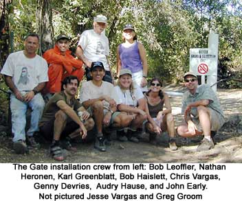
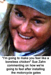
Motorcycle
Gate installation
The
motorcycle gate installation trail work project was 75% completed in July. This
was the last project working with Sue and it was both a happy and sad time. We
have one gate left to install at the top of Trabuco Canyon Trail and the Main
Divide and we plan on finishing this during the 2000-2001 trail work program.
Sue will be missed and we are happy
for her promoting which was well deserved. We thank her for the opportunity to
work with her and know her as a good friend to all mountain bikers.
We also thank District Ranger Clem La Grosa for his support and work in protecting the forest for all forest users.
It's
a Boy!
Carl
Winefordner
Dear
All,
It's a boy!!!
His name is Ian Andrew. Mary
Jo and I went to the hospital at 2:00AM Saturday morning.
Almost 22 hours later the little guy was born. It was an incredibly moving experience for both of us.
Ian was born at 8 pounds, 4 ounces and 20.5 inches long.
We originally thought he was bald but he actually has lots of fine blond
hair.
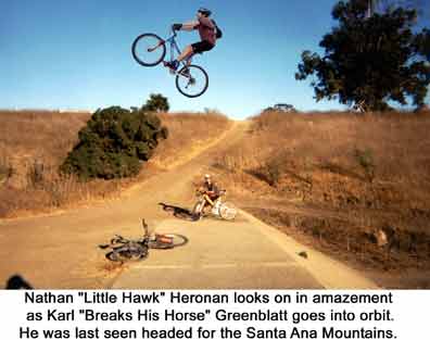
Karl
"Breaks His Horse" Greenblatt goes into orbit
On a
recent ride in Near Huntington Beach Central Park, Karl "Breaks His Horse"
Greenblatt attempted a BMX Jump that Nathan "Little Hawk" Heronen took us
to. Karl attempted the jump but approached the jump with too much speed. He took
off on the jump and has not been seen since.
Featured Stories
4 Parks and a Barbecue
Todd "Warrior's Spirit" Brown
I figured a bike ride named 4 Parks and A Barbecue would appear on the surface to be innocuous and have the desired effect of getting a few good riders to join me on a personal challenge. It worked, better than I imagined.
Saturday morning, July 1st, 2000 thirteen riders assembled at the main entrance to Whiting Ranch. We officially rolled out by 7:00 am. By 7:30 am the war of attrition had begun. A rider I had yet to meet managed to hook up with a local, friendly cactus. After we all got untangled from the pile up we scooted on down the remaining trails and regrouped at the upper parking lot. After a head count of twelve, Garrett assured us that his friend John was a big boy and would catch us later. Our first casualty was gone in less than 45 minutes, and so we exited Whiting Ranch.
The next section was the Aliso Creek Bike Trail. This down hill trail (it follows a creek bed) is paved and kept us away from the cars as we journeyed to our next off-road adventure. By my calculations this would take us another 45 minutes instead it took 35 minutes. We were stopping more than I planned and we were riding faster than I planned, a combination that worked for me and everyone else.
The bike trail dumped us out fresh at the east entrance to Aliso/Woods Canyon
Park. This is a great mountain bike area, known for it's many challenging
and steep trails. As we entered the park we also met up with Susie and four
of her girlfriends. This foxy group had left about 15 minutes before we did
from Whiting Ranch. We now had 17 in our group.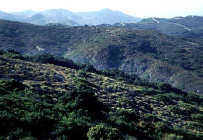
First on the agenda was the climb up Mathis. This long steep climb quickly spread our group out. Each rider going according to his or her pace. Way up the trail, moving fast I could see my wifey. She looked great, smoothly, elegantly climbing the rugged trail. Nearly to the top we assembled at the trailhead of JT's, aka Almost Hans Rey. Most of our group had never done this trail and they gathered at the edge of the sandstone rock we would roll over before the plunge down a steep, rutted trail. Marisa, throwing caution to the wind, rode off confidently. I looked on with surprise as her head slipped below the big rock's edge. Suddenly, the group made a collective gasp and lurched forward. I pressed through to take a look at the prone body. For a moment she didn't move. Slowly she came back to life. Elaine, always prepared, quickly applied the needed medical attention. At the same time, Keith informed me that he wasn't feeling too hot and that he would be meeting us later on the route. Figuring I'd better keep us moving or we might not ever finish I decided to head down and let Marisa's boyfriend, Jim, know of the damage. Calvin came down behind me with a few flesh wounds, but more troubling was the fact that his saddle had torn off the rails. He pressed it back on as Marisa joined us. We parted with Susie's group and continued on up Cholla. Thankfully, this was a non-event.
Rather than go down Telonics we were encouraged to take Stair Steps. This is an interesting trail whose main characteristics are the large sections of sandstone. At first sandstone seems like a fun surface, it's sort of smooth and there is great traction. But once you've fallen on it you realize it is just like a giant power sander waiting to grind your skin to the bone and the bone to the marrow. We dropped down with cautious precision. Things were going smoothly until… Marisa went face (as in dirt in her mouth) first over the handlebars. It must have been like a virus because I soon found myself pulling the same stunt. Peter thought this was great as it had been seven years since the last time he saw me crash. I didn't laugh. Then Bill caught the bug. We took inventory, all bodies and parts were accounted for in the shade of a loyal water tank at the canyon's edge.
Back on the road we zipped to downtown Laguna Beach and took a serpentine route
to El Morro, the third park. On the road over several of the group asked if
I thought we were about half way through the ride. I could only smile and
say, "well we have been through two of the four parks." We fueled up at
the ranger station at about 10:30am. The heat was starting to increase as
we rode up No Dogs. Originally, I had planned on several climbs here but I
made an executive decision and decided to go with a perimeter run. Someone,
who shall remain nameless, recommended we finish El Morro with a trail that
shall remain nameless. I can only say it was very sweet, and we were all
very appreciative of the experience.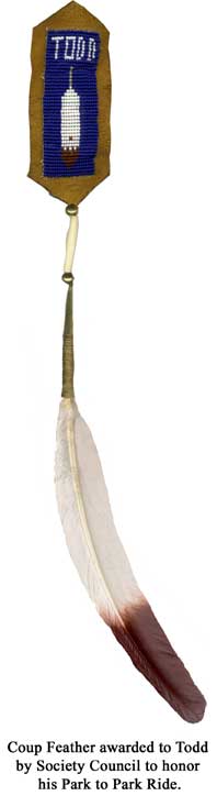
Like a gang of Harley riders we pulled into the Circle K parking lot at Crescent Bay. Everyone picking their poison. Doughnuts, nuts, Gatorade, pretzels, water, etc. as for me: Dr. Pepper. As I was being quizzed, "are we half way done, yet?" (not the first or last time, nor the correct time!) Calvin's front tire slowly leaked out a last gasp. Fueled and aired we pulled out and went straight up to the road above that would keep us away from the traffic.
It was on this steep road climbing, away from the coast that it fully dawned on me that Garrett was riding a single-speed bike with an horrendous gear for climbing. Zigzagging up the hill he actually smiled when I let him know the next climb was the fire road out of Canyon Acres. "Where's that?" someone asked. "Well, you see that fire road going straight up to the Top of the World that looks totally unrideable?" I responded. "Yep." "That's the more makeable section of the road." "Ouch!"
"Ouch" was an understatement. I think only one of the eleven riders was able to make it up without touching down a foot. What an animal! The climb was nearly vertical, freshly graded and loose, and completely exposed to the noon day sun. I assured everyone there would be a strong tail wind pushing us up, and there was. The wind moved about the same speed we did which gave the oppressive heat the opportunity to completely blast us from bottom to top. Here, at the top, I was confident in saying that we were now about fifty percent complete, time-wise.
From the Top of the World we dropped down to Mathis again to go to a trail called Car Wreck. Warned and wary, four riders opted to meet us at the exit, the rest of us went down the final technical drop of the day. Pete and I went last. As we approached a particularly steep section that I had previously walked down I saw some of the gang perched atop the edge. Feeling like the fearless leader I decided to go for it. I had a good flow going and cleaned it all!
From Car Wreck we rode as much single track as we could then road out the main exit by the Chapel. Those who opted out of the steeps met us there in the still shade. Looking at the sweat beading on my arm had me longing for a long tunnel with misting machines.
We gathered our gang and mustered our strength to begin what I had predicted would be the most sinister section of the ride. In the morning the paved bike trail was a happy, cool glide. Now the wind was at our backs, blowing about the same speed we were moving. It provided a negligible relief. As we began the 10 or 12 miles of pavement back towards Cook's Corner it seemed like this would be a nice break. Instead it was a will and leg breaker. When we reached my parked car a few miles below Cook's Corner, stocked with supplies, we lost 4 riders. It was particularly difficult to see them bail out.
Up ahead still waited the road climb to the Santiago Truck Trail, and the trail itself. Even when fresh these climbs are hard. There are two sections that required more than power, they needed will power. Fragments of the group bumped and pumped along the dusty trail. At 3 in the afternoon, this was truly the heat of the day and wind was listless. The strange magnetic pull of seeing a fellow rider up ahead was stretched to it's limit, but it held and once again we regrouped at the Luge. Sadly, Colleen made the decision to go down from here… so close.
We rode on and up to another trail that would lead us down to the canyon floor. Before
descending I took stock in the ranks. Looks: bad. Equipment: stressed. Supplies: low. Spirit: lifting
by the thought of a long downhill. On the way down, Pete got one of the few
flats. There were no land speed records to be set here, common sense
combined with exhaustion to keep the velocity sane. We spilled out on the
road and coasted over to the local (though seemingly caught in a time warp)
convenience store. Quality fuel was purchased, like ice cream, soda pop,
candy, nuts. It all tasted good and quickly vanished.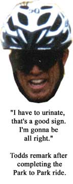
I'd already used the "this is the last climb" line about 10 times, and I was getting ready to drop it again. We cruised through O'Neill Park and wound our way up to the open single track connector through Hidden Ridge and back on to the bike trail. It took 2 "this is the last climb's" to get us there, and I had 2 more ready to loose as we entered the fire road which goes over to the upper parking lot at Whiting Ranch. Politely, I was asked to knock it off, just stay out front and get us home. "Okay".
Dusty, sweaty and sticky Pete and I rode up to my house. The rest drove up from the parking lot. What a feast awaited us! But first we rotated through the showers and so we would at least smell human. Chris Vargas and the trail crew who had been doing trail maintenance showed up about the same time.
Susie and her gang had prepared a true feast. It
was pot luck, which went well with all the good luck of the day. The
scrapes and bruises, the aching all diminished and faded. The bonds we had
made and strengthened matched our thirst and hunger. We didn't have all
the cast or the goofy music and fireworks like a typical final scene of Star
Wars, but we felt good. Together we knew the force was with us.
(Note: No one had an odometer, altimeter or camera. Todd also
participated in this years Leadville 100 and will cover that ride in the
December issue of Smoke Signals)
Summer Climbing/Riding Adventure Part 1
Tom Rogers
I went climbing in the Sierra's this past weekend. I planned on climbing Mt Langley (14,024ft.) Saturday, and then doing the White Mountain From Bishop, Sunday, it tops out at 14,245 ft. I felt that the task at hand was feasible but would require a lot of physical endurance.
It turned out that the first mountain I climbed, Mt. Langley @ 14, 024 ft. was incredible! I started at 5:00AM from about 7k ft. One mile into it the trail turned to a bush whack! This peak as I found out is not done much from this approach. It is done from the south with a very easy scramble. It took all of about three hours of blasting through mansanita bushes and creek crossings. I reached an elevation of about 11.5 - 12k. Here I refilled my camelback from the stream with my filter and off loaded my extra clothing that I could tell I wouldn't need. The day was perfect; Shorts and a tee shirt! I did carry a few extra pieces just in case....you never know.
I proceeded up a very steep chute in which I had to use cramp-ons on my running shoes. This was a lot steeper than told, but after some careful stair cutting I was able to surmount the main summit ridge in about 2.5 hrs. I was the only one up there and it was a killer view. I then proceeded over to a loose rock chute that wasn't as steep but full of loose rock! Everything else was just a walk in the park. I was back at the car by 2:00. 8 hours round trip!!
I then proceed to the local hot creek for some lunch and a good hot soak in the creek. I was feeling a little thrashed but I ate lots and powered down the Champion Nutrition ( Pro Score, JSF) I used all Champions product throughout my climb; MET Endurance, Muscle Nitro, JSF, and I feel the best fluid replacement drink ever invented REVENGE. Thanks IRON!
The following day I was planning to ride my MTB to the top of the White Mountains (14, 245 FT.) from Bishop (aprox. 4500 FT). I packed my bag the day before with 2 camelbacks (70 oz.) with REVENGE, two bottles of Met Endurance(on ice), a bag of dried fruit, and 8 power bars. I also took some extra clothes for the extreme weather that can come in at the higher elevations. My pack was about 12 - 15 lbs, pretty light for climbing but a lot heavier than I wanted it. I left at 5 am again to beat the morning heat. It was a cool morning, and I was feeling a little tight but with good spirits! The first task on the ride was to ride up Silver Canyon. This canyon rises to aprox. 11,000 ft. in 13.5 miles! It was one of the steepest roads I've ever ridden, or a least it felt that way. This took almost 3 hrs!
Ouch!! I took a break, ate some food. I then thought that the next 10 miles to the main parking area ( where most sane people start this climb) would be an easy ridge ride: Wrong!!! This fire road was all above 11K with a lot of gain and descents.
It took another 2.5 hours to reach the parking lot. I am now 6 hours into the ride. I was pushing hard on this section to try to keep the duration at a minimum. This was the longest 10 miles I've ever ridden. So now that I've done the hardest climb I'd ever done and the longest ten miles I'd ever done, it was time to do summit the Whites! I was a bit spent, but I had to try. I felt I could a least make it up to Bancroft Laboratory (high elevation lab)
Ouch!
I talked to somebody working there and they said I could get water if I needed,
and I did! I was down to half a camelback and one bottle of Met E left. After
hearing that I could restock on H2O, I was definitely
going to try to summit. I was real close to turning around here due to lack of
supplies. I was sucking down the fluids!!!!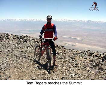
I then proceeded to the summit via a steep loose rocky road / trail. I felt great. I was able to dig in and rise to the occasion! I summited in another 2.5 hours (8hours and 23minutes to the summit) the second longest ride I've ever done!! Oh, I'm only halfway!!!?
I lucked out when I reached the summit. Two good friends of mine who knew I was going to the Whites, were sitting at the summit ! That was the most expensive peanut butter and jelly sandwich I've ever had, but the best!!! I then descended with elation and excitement!!! It was totally worth the pain. The descent was technical and steep. (Joel you would have dug it!!)
Seeing that it took considerably longer to summit than planned and the previous summit the day before, I opted for a ride from the parking lot to the top of Silver Canyon. There was no way I was not going to do that drop-in!!! A bit o trivia...this road was used for the Ultimate Kamikaze in 1988'. Joe Sloup and Johnny Tomac battled it out, while I lost my rear break one mile into the race (not good!). I believe it was Joe who won the race. It was back in the full rigid days and it took 45 minutes and change.
I had my Walkman with The Red Hot Chili Peppers on max. volume and dropped in like it was my second chance to race, The Ultimate Kamikaze!! Mind you that I was sporting a sweetly set-up Tomac 78 Special with an X-Vert Air @ 105mm travel!!! Ok I cheated a little over our old rigid rides.
Gotta Love it. 37 minute flat after 10+ hours of riding. I was back in the valley with a short 4.5 miles into a headwind to my car. What a weekend!!
Keep'n it Epic,
Happy Fourth of July!!!
Tom
Rogers
(P.S. this is the highest place you can ride in California!!)
Editors
Note: Tom Rogers is the Race Manager for Answer/Manitou and the Second Place
Finisher in this years' Vision Quest. Next
issue: Tom's Cascade Climb.
Dial
911
James Cudworth
So you think there are friends in this
world but now I wonder after believing the words of childhood friend Jeff
Leenhouts… The younger brother of Dick who we always sent to the outfield to
shag fly's in the back yard baseball ball games. Now over 6', 200 plus and a
biking machine. I take back every cruel thing I did to him while growing up.
Jeff's plan is to convince all his so called FRIENDS to join him on a Mountain
bike-training ride in preparation for the race across the sky called the
Leadville 100. In Jeff's words yea "it's a good training ride, hard but
you get to prepare for the feel elevation" Sounds simple enough doesn't it?
Here is the story of how Jeff punished his now ex-friends with on a ride to the
top of White Mountain which peaks at 14200 feet.
Training ride Email comes: meet us at 6:00 at the Sizzler in Bishop. We'll camp just outside of town start early Saturday morning. OK, I'm in. Start the drive Friday afternoon and 30 minutes into it the drive my AC dies. Bummer, still have the desert to cross must be an omen to the rest of the weekend (Hot). Get to Bishop meet the 6 other victims and the sag wagon driver. We set up camp and prepare for the ride next day. Jeff announces we start at 4:30AM with lights on the bike. OK I think, this doesn't sound good but it's like Leadville only earlier by an hour and a half. Opened my sleeping bag and fell asleep under the stars only to be awakened by Jeff singing an Aerosmith (Walking the dog) song rousting every one up. Bad dream I thought!
So the ride starts 4:30 and for the first 8 miles we are climbing a loose dirt switchback fire road with a grade between 20 and 30%. Even the corners were steep and can think of three that were actually flat. I'm glad it was dark cause actually seeing how steep this climb is may have made it even harder. Three hours, one gallon of water later we get to the top of the ridge. From start of ride total elevation gain is 6K feet and ridge is at 10K feet. Good morning America, What was I thinking? We stop at our sag wagon for breakfast. Chief Cookie prepared pancakes, power bars and carbo load drink. We all hovered and the food is consumed in seconds. Remove our lights, added sunscreen, fill water bottles and off to the second stage.
We start again to complete the next 15-mile section now at 10K feet and beginning to feel elevation. Road is some easy rolling hills past a very old Bristol Pine sanctuary. A little down hill and then wham right into a 1000 foot climb so steep this section of dirt road was paved for traction. Starting to feel the pain because even low gear was not enough for cycling comfort. Every one made it fine but we were glad that was done and the rolling hills started again. I'm thinking this is the easy part of the ride but not considering how these 2K feet of climb would feel after completing the summit climb. Next stop was the entrance gate for the final assent to the top of White Mountain.
By
now it's near lunchtime and the Sag wagon is again waiting. We devour
sandwiches in each hand, there gone in 60 seconds. Fill our water and prepare
for the final climb. This is were I begin to really hate Jeff… I don't know
maybe it's the elevation setting in at 11K or maybe it's his answer to
"where's the summit". Jeff answers, "ya it's only 7 miles over
there". So I'm looking around and don't see it. It's over that hill he
says. Realizing Jeff's lack of adjectives I know I'm in trouble. We start
again first climb is not so difficult but I'm beginning to really suck wind
now. Remembering this is the feeling I'm suppose to get and endure from this
training ride. You know elevation: no air, rapid breathing, pounding head, dead
legs all that fun stuff. Anyway, we get to a plateau of this climb at the
University of California Research center and take a break. Still no summit in
but the crest of the hill is near. Start for the crest and road becomes a double
track of really loose rocky terrain which required walking at some spots. I'm
thinking in between breaths Boy I hope this trail firms up a bit cause I'm
beat riding this. So we get to the
crest and now I really hate Jeff… There it is "the summit of White
Mountain" I begin talking like a sailor cause to begin the final climb we
first have to drop down 1500 feet and the trail is a boulder field. I'm
bumming out, feeling beat, every one passes me and even the Sierra club hikers
are not very friendly. "Bikes on our tail isn't that illegal". Whatever I
say they just never see stupid people like us trying such a challenge. Why do
they call these things mountain bikes anyway. 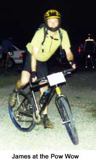
Thinking, I got this far, I have been training hard for 3 months, I'm going to make it to the summit. So I just keep moving and I'm half way up the summit at 13K in elevation. I'm walking the bike now cause it is too loose to ride with the strength I have. My body feels really heavy and I'm doing this ten steps, rest, ten steps, rest thing. Taking forever. I hear every one yelling from the summit, busting my ass about being last. I got five short switchbacks to go and I look at the un-ride able trail, look at me carrying the bike and decide to drop it there. So like a zombie I hike the last 5 minuets while they are yelling "bring your bike" Sailor talk was my response to that BS.
Finally I make it to the summit of White Mountain at 14200 feet. I still hate Jeff for his lame description of this body wrecking, dehydrating, wind sucking training ride. We take a couple of group photos and then on our way. Feeling relieved it was down hill from here I remember now all the valleys that still have to be climbed. Bummer but at least we are heading home. Back to the sag wagon we ate again, refilled our water and headed out. Just 23 miles to go I'm feeling better cause were back at 11K feet and I start to spin again.
Except for the 2K of short climbs in the middle section, the rest of the ride was pretty fun as we just bombed down the hills full speed holding on to the bike. A full suspension bike would have felt good here cause on a hard tail the last 12 miles was mainly a standing ride. Coming in on the home stretch hitting the stream crossings felt great as the temperature increased while we approached the camp ground in Bishop at 3500 feet. Finally we arrive back at the campground it's 7:30 PM… That's 15 hours of hard riding. Either I must be mentally sick, an endorphin junky or both. Counseling is going to cost me a fortune.
What a ride and a test of endurance training… For sure the toughest some of us have ever accomplished. And to think this is an annual outing for Jeff after he tried it as a race. Race caused a heart attack in a participant resulting in promoters to never try again. But we all survived this 15 hour, 60 mile, 14500 feet of climbing with a peak elevation of 14200 feet. No one was hurt and Jeff (AKA "Alpha Dog") is really a great friend to have. Next trip report from the Colorado Leadville 100.
James
Bob "Keeps Many Trails" Loeffler
For those of you who have yet to "c'mon down" to Cuyamaca for the
bi annual Single Tracks and Single Malts ride, here's a brief rundown of last spring's ride:
It was one of those Spring Fridays that seemed to glow, and hanging at
work just wasn't in the game plan. The Outback had been packed since Thursday, and my freshly cleaned and lubed carbon steed sat waiting to
adorn the roof rack for the trip south. I ran through my work's "to do" list by lunch, made some lame excuse to the rest of the office about a
"doctor's" appointment, and bolted for home. An hour later, Mr. Subaru and I were hurtling down the 5 with Ms. Trek riding piggyback and holding
on for dear life.
I made the exit in record time, peeling off the 8 and pointing north on
79 in just under 90 minutes (don't try this at home, folks). Man, did I wanna be there! The afternoon sun had the hills ablaze with the green
radiance of Spring, and the air was so fresh I swear it gave me a stiffy (hey, wood in the woods is good, right?). Hung a left into the Green
River campground, checked in with Mr. Friendly Type Ranger and parked the car in the best site (#75 since you asked) in camp and swore not to
drive again 'till it was time to go home (swore so well that I promptly lost my keys... not to be found 'till Sunday). Tom Taylor had already
arrived and his truck sans bike meant the bastard was sneaking in an early ride.
I decided to hang out, set up my tent and throw a new set of sneakers on
the bike. Keith and Jim pulled in and proceeded to unload several coolers of food (this army travels on it's stomach) and Tom returned to camp
with tales of accidentally ending up on some wilderness trail. All of us then conceded that a bond with nature was in
order and a short hike to the falls would do the trick. With lots of boulders to hop and streams 'to jump, it wouldn't be long before
someone took a dive, and that someone would be me... ass first into a nice little
pool, dancing all the way. A good laugh was had by all, photos taken, and a run back to camp to see who else had wandered in.
The evening fire was started while we watched Dodge Dart erect his canvas
palace, replete with velour covered "queen" sized air mattress ( oh Chris, you brute), as Paul ran around succumbing to Salina's every whim
(crack that whip!). A pretty mellow evening over all considering Saturday's endeavor. Most of us had our bags zipped by ten o'clock.
Saturday dawned clear, bright and balmy. By
6 am, most riders were up doing the usual pre ride preps: emptying and filling bladders, consuming
and packing food. Except for Gerritt... The night before he had produced a "Safeway" house brand of bourbon in all of it's plastic bottled
splendor which was greeted by several snickers and a few jeers. So, in his infinite wisdom, he decided it would make a superb breakfast
beverage. I concurred as did several other thirsty souls. Ah sour mash, breakfast of champions!
In spite of our selves, we all managed to make it to the trail head by 8
am, Where we were joined by several riders who had driven down that morning. After hearing about the bourbon breakfast,
boy were they jealous!
Off we went like a herd of turtles, but the rabbits in the group soon
took the lead as the first hill did it's job of spreading everyone out. I hardly noticed the climb as the fragrance of pine, sage and juniper kept
me gulping down the fresh, clear air. At the top I dutifully waited (required of el jeffe de la ride-o), but frustration was not an issue...
this ride is for anybody who can pedal 40 miles, no matter what their speed is. I was more anxious for everyone to experience the
meadows full of wildflowers than to ride fast. As we pedaled out of the trees and into
the high meadow, the lands around us seemed to explode with colors. Brilliant reds and oranges, deep blues and purples, sparkling whites and
yellows... it seemed as if every wild flower imaginable was blooming.
We regrouped at Granite Spring, some of us lounging on the hand hewn
wooden benches or checking out the rough maps on the park signs. After all hands were accounted for, we took of for the first section of single
track, again through high meadows ablaze with colors and views to stop you dead in your tracks. And speaking of blazing, a few of us opted for
warp speed down a very rutted and twisty descent to Pine Valley fire road, where again we huddled and all decided to climb the Indian Springs
Trail instead of the double track . And yep, it's rocky techno at it's finest, which led a few riders to question their quick agreement with the
rest of crew.
 After making sure everyone was on the right track, I
decided to raise my personal best by hammering to Champagne Pass ( after all, I wasn't gonna feel this fresh for rest of the
day). I soon caught up with Tom Taylor, surprising him as much as myself. It was just too
good of a day! From the pass it was a wild holler across the ridge to Pioneer Mail, our well deserved lunch spot, where Paul showed us how he
packed an entire Trader Joe's into one HydraPak. Awesome spread, Mr. Miller... and thanks for sharing.
After making sure everyone was on the right track, I
decided to raise my personal best by hammering to Champagne Pass ( after all, I wasn't gonna feel this fresh for rest of the
day). I soon caught up with Tom Taylor, surprising him as much as myself. It was just too
good of a day! From the pass it was a wild holler across the ridge to Pioneer Mail, our well deserved lunch spot, where Paul showed us how he
packed an entire Trader Joe's into one HydraPak. Awesome spread, Mr. Miller... and thanks for sharing.
We were all yucking it up when we began to realize someone was
missing... our very own version of Mr. Clean, the venerable Art Zipple. "Where the hell is Swerve?" we all asked. "Don't much matter, gotta go
find 'im" was my reply. Gerritt (bless his skinny little heart) volunteered to help me with the search, with him taking the high road and
I wandering the low. We met up at Indian Spring after single speed Slingerland found Swerve nursing a sore knee at the pass and suggested
that he head back to camp and indulge in pain killing substances. As we
climbed out of Indian Valley and back to the lunch spot, Gerritt and I congrat'ed each other on the rescue effort AND the extra credit
miles (and thanks again, Mr. Slingerland, for your help).
We hit Sunrise highway and few miles of pavement later, we were all
refilling at the Noble Canyon Trail head water stop. Back on the road for a couple more miles of asphalt, made easy by some breathtaking views of
the Anza-Borrego desert.
After finding the entrance to Big Laguna Lake
Trail, and losing a couple of day riders to "time constraints", I cautioned all about the increased presence of hikers to be expected
through the next swooping, diving, dying-to-be-hammered section of single track.
The trail around Laguna Lake was a blast, in spite of the occasional
scowling Sierra Clubber (lighten up, daddy-o, or Johnny Muir's gonna strike you down 'n' NEVER let you into hiker heaven). Again, more damn
flowers! Damn freackin' beeotiful, that is! After we all cleared the cattle gate at Noble and gathered for one more
photo op, the hammer went down and it was peddle to the metal all the way down to Indian Springs Trail. I managed to keep the full
suspension boys honest by keeping my hardtail hot on their heels all the way down to the
water crossing. Again, another surprised look from Taylor.
But the surprise didn't last long as we began the ascent up the backside
of Indian Creek. Although the climb out seems to get shorter every year, those few "extra credit" miles teamed up with the all those
flippin' rocks and kept me mid pack, which I suppose is where I needed to be. I was feeling pretty whacked when cheers from Tom, Keith and Tim kept me
from dabbin' on that tight, rocky switchback near the top... thanks, guys!
A final re group and film record atop Champagne Pass and it was a whoop
and holler speed fest back down that section of Indian Creek Trail we had climbed what seemed an
eternity ago. I did my best to push the down hill envelope but the full boing boys easily pulled away from this toasted
hardtail. I decided to just kick back and enjoy the scenery. The afternoon breeze turned the fields into undulating waves of bright green
with crests of purple , white and red. All the trees sported new crowns of leaves that had me humming a Loreena McKennit tune. Ah yes, mellow
peddling at it's best. The final climb, the final descent; these are the simple pleasures...
Yeah baby, now that's a ride!
Back at camp, a few more simple pleasures came about. Like finding the
Vicodan in my ditty bag, or not needing quarters for the shower (gotta love anything that's free or kills
pain). After cleaning up it was time for happy hour and food fest. Dave and Colette mixed up the martinis, Paul and Salina uncorked the tequila,
while the rest of the boys broke out the beer. Only Keith , Karl and I remained true to tradition and stuck with Scotch.
Keith had a Highland, I an Islay, but Karl took the prize when he produced a fine bottle of The Balvenie, and a Doublewood at that. Yeah,
Splat , ya did good! Needless to say, nary a drop was left by the end of the evening.
With cocktails flowing, it was time for dinner. The fire was stoked by
Swerve and the Sprockethead contingent as steaks and salmon waited eagerly for the
coals. Veggies were cooked, salads were tossed, spuds were nestled in the embers. But the biggest treat was when Keith and Jim whipped out their
giant homemade sausages. Man, those suckers were HUGE! Slapped those pups on the fire and let 'em sizzle, then pulled 'em off and sliced 'em up.
Damn tasty! Yee Ha, what a meal!
As the sun sank, so did we into a fat and happy stupor 'round the
ol" campfire. And as with any gathering of goombahs grouped near flames, stupid fire pit tricks were sure to ensue. First there was the
"see how much we can cook that piece of steak 'till it doesn't taste like
meat anymore trick", then the ever popular melt the beer bottle and stretch
it trick. There were more, but you get the picture... Then it was joke time. Send the wimmen and chillins and
politcally corrects outta hear 'cause the air's gonna burn! Tom Taylor took the lead early and never gave it up while the rest of us guffawed
our guts out and vainly struggled to commit at least one of his lines to memory. That boy should do stand-up.
A brief lull gave Paul and Salina a chance to light candles and present a
birthday cake (homemade,too) to Keith and I. A rousing round of "Happy Birthday" was sung and shouts of "mas wood!" prompted the flames higher,
which had funny way of bringing out more alcohol... interesting correlation.
Soon the fire began to fade as did many of the revelers. While most
crawled off to tents and bags, a few hard cores including Brett, Karl and myself chose to watch flames die while we solved the world's problems
between sips of single malt. But then even toughest began to topple and as Brett banked the coals the rest of us stumbled off into the darkness
and our cozy nylon cocoons.
Hey Sunday! Ya here already? Good thing Dave McBride's in a flapjack
frenzy. Man that guy can do pancakes! And what a great cure for that overhung feeling. Just ask
Gerritt. Something tells me he won't be mixing martinis with bourbon, scotch and
beer in the future; no matter what George Thorogood says. But I gotta hand it to the
S O B, he went off and rode. A few of us opted off the saddles and tied on boots while eying a local
summit. It wasn't long before we found ourselves atop a very windy and sunny rock cap, talking to the local crows about the other tourists. And
it didn't take long for the downhill to turn into a running race with Jim and I dicing it out in front.
Back to the cars and we all knew it was time to pack it in. Paul and Sally took of to do the Julian thing while the rest of us returned to
camp to pack.
I've never been good with long goodbyes, especially after a killer
weekend with an awesome group of friends. So just pack it up, pack it in a quick wave and many
thank you's and I'm gone
See Ya... next time!
Trail Work
"Legs of Iron" Hahn has been working on brushing the Viejo Tie over the summer and believes he will finish it before we do our work on Chiquita. Colleen "Scalps Many Braves" Rashford came upon James when he was working and emailed me this description:
"My friend Karen & I saw Jim up there at the trail. He wasn't kidding & was modest when he said he just did some minor maintenance......he did awesome! He even had a few scrapes to remind him at the end of the ride!"
"Lone Wolf" Reynolds has been brushing both White Hawks Trail and the Joplin Trail. If you see someone working on these trails that looks like a cross between Big Foot and Paul Bunyan, that's Lone Wolf.
We will be working on the following trails during the 2000-2001 Trail Work
Program:
· Chiquita Trail - Saturday November 11th, major brushing. Meet at Upper Blue Jay Campground.
· Holy Jim Trail - January (date to be announced) minor brushing.
· Trabuco Creek Trail - February (date to be announced) minor brushing.
· Holy Jim Trail - April (date to be announced) switch back repair.
· Installation of the last motorcycle gate at the Trabuco Canyon Trail and the Main Divide - May (Date to be announced).
Closing Thoughts
"Counts Many Coup" Beck
recently place first in the RAD Challenge, "Little Hawk" Heronen was the
first youth.
Maple Springs Road (the road past the Forestry gate at the end of Silverado Canyon Road), which was closed for the Arroyo Toad breeding season, is now open to all but vehicles. They are currently doing repairs on the water crossings and will open it up to vehicles when this work is complete.
A good friend and spiritual advisor to the club, Al Sanchez, was recently killed in a traffic accident. Al is a Tribal Member of the Jauneno Band of Mission Indians and the keeper of the Tribal Staff. I will think of you Al when I see our brother Hawk in the sky. We will share the pipe when I join you.
The
Toad Festival is coming up Saturday October 21st. If you haven't
sent your application do it ASAP because it will sell out. We are also having a
costume contest for the best-dressed toad, so if you're a creative type start
making your costume now. Well that's it for this issue; see you at the Toad
Festival.
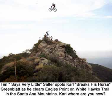
Late Breaking News
Flash
"Breaks His Horse" Greenblatt was recently spotted over White Hawk's trail during a ride done by "Little Hawk" Heronen, "Says Very Little" Salter, "Lone Wolf" Reynolds, "Hurts Many Braves" Rashford and Calvin Mulder. The picture below was taken where he was spotted on the trail.
Breaks His Horse was spotted heading east. Keep your eyes on the lookout for him.